
Make a donation
Gear up for your next adventure:
As an Amazon Associate, this site earns from qualifying purchases at no extra cost to you.
Connersville topographic map
Click on the map to display elevation.
Make a donation
Gear up for your next adventure:
As an Amazon Associate, this site earns from qualifying purchases at no extra cost to you.
Connersville
Most of the town is located on the north bank of the west fork of the Whitewater River. The town is at modest elevation, a little over 800 feet (240 m) above sea level. The local area has nearly flat to gently rolling topography. The local region (and all of Fayette County and the state of Indiana) are part of the Eastern (U.S.) Broadleaf Forest Environment biome. Much of the surrounding Whitewater Valley vegetation would be classified as riparian woodland or gallery forest. There are 124 native tree species, including 17 varieties of oak, as well as black walnut, sycamore, and tulip tree (yellow poplar), the state tree. Fruit trees—apple, cherry, peach, and pear—are common. Common native mammals are the red fox, common cottontail, muskrat, raccoon, opossum, and several types of squirrel.
Make a donation
Gear up for your next adventure:
As an Amazon Associate, this site earns from qualifying purchases at no extra cost to you.
About this map
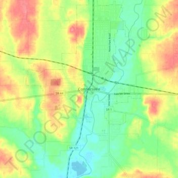
Name: Connersville topographic map, elevation, terrain.
Location: Connersville, Fayette County, Indiana, 47331, United States (39.60116 -85.18107 39.68116 -85.10107)
Average elevation: 883 ft
Minimum elevation: 774 ft
Maximum elevation: 1,027 ft
Fayette County trails, hiking, mountain biking, running and outdoor activities
Make a donation
Gear up for your next adventure:
As an Amazon Associate, this site earns from qualifying purchases at no extra cost to you.