
Make a donation
Gear up for your next adventure:
As an Amazon Associate, this site earns from qualifying purchases at no extra cost to you.
Vernon topographic map
Click on the map to display elevation.
Make a donation
Gear up for your next adventure:
As an Amazon Associate, this site earns from qualifying purchases at no extra cost to you.
About this map
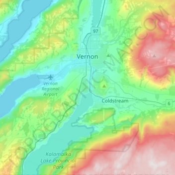
Name: Vernon topographic map, elevation, terrain.
Average elevation: 2,218 ft
Minimum elevation: 1,112 ft
Maximum elevation: 4,875 ft
Make a donation
Gear up for your next adventure:
As an Amazon Associate, this site earns from qualifying purchases at no extra cost to you.
Other topographic maps
Click on a map to view its topography, its elevation and its terrain.
Cherryville
Canada > British Columbia > Regional District of North Okanagan > Area E (Cherryville/East Creighton)
Average elevation: 2,110 ft
Enderby
Canada > British Columbia > Regional District of North Okanagan > Enderby > Enderby
Latitude-Longitude: 50°33′03.0″N 119°08′22.7″W / 50.550833°N 119.139639°W / 50.550833; -119.139639 elevation: 360 metres
Average elevation: 1,677 ft
Davis Peak
Canada > British Columbia > Regional District of North Okanagan > Area F (Grindrod/Ashton Creek/Mabel Lake)
Average elevation: 6,604 ft