
Make a donation
Gear up for your next adventure:
As an Amazon Associate, this site earns from qualifying purchases at no extra cost to you.
Guatín topographic map
Click on the map to display elevation.
Make a donation
Gear up for your next adventure:
As an Amazon Associate, this site earns from qualifying purchases at no extra cost to you.
About this map
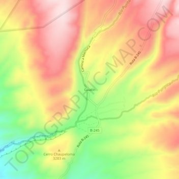
Name: Guatín topographic map, elevation, terrain.
Average elevation: 10,745 ft
Minimum elevation: 10,089 ft
Maximum elevation: 11,257 ft
Make a donation
Gear up for your next adventure:
As an Amazon Associate, this site earns from qualifying purchases at no extra cost to you.
Other topographic maps
Click on a map to view its topography, its elevation and its terrain.
Laguna Lejía
Chile > Antofagasta Region > Provincia de El Loa > San Pedro de Atacama
Lejía Lake is a circular, shallow lake at an elevation of 4,325 metres (14,190 ft) with a surface area of 1.9 square kilometres (0.73 sq mi) or 2 square kilometres (0.77 sq mi). It is a polymictic lake which freezes over occasionally and whose waters are turned over quickly, mainly through evaporation. Winds…
Average elevation: 14,242 ft