Geolocate

Porompat topographic map

Click on the map to display elevation.

About this map

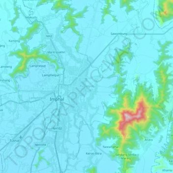
Name: Porompat topographic map, elevation, terrain.

Location: Porompat, Imphal East District, Manipur, India (24.71864 93.89542 24.90691 94.01033)

Average elevation: 2,694 ft

Minimum elevation: 2,523 ft

Maximum elevation: 5,108 ft

Other topographic maps

Click on a map to view its topography, its elevation and its terrain.

Leimakhong

India > Manipur

Average elevation: 3,173 ft

Tengnoupal

India > Manipur > Tengnoupal tehsil

Average elevation: 4,003 ft

Gear up for your next adventure:

🦟Ultrasonic Repellers - Create a bug-free zone at your camp or rest stop
🥄Camping Utensil Set - Lightweight utensils for outdoor meals
🧼Biodegradable Camping Soap - Eco‑friendly soap for outdoor hygiene
🪑Portable Camp Table - Compact table for campsite meals
🎒Gear Packing Cubes - Organize your backpack efficiently

As an Amazon Associate, this site earns from qualifying purchases at no extra cost to you.