Geolocate

Hazel topographic map

Click on the map to display elevation.

About this map

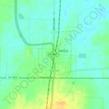
Name: Hazel topographic map, elevation, terrain.

Location: Hazel, Calloway County, Kentucky, United States (36.50048 -88.33078 36.51198 -88.32061)

Average elevation: 548 ft

Minimum elevation: 515 ft

Maximum elevation: 607 ft

Calloway County trails, hiking, mountain biking, running and outdoor activities

Other topographic maps

Click on a map to view its topography, its elevation and its terrain.

Shiloh

United States > Kentucky > Calloway County

Average elevation: 499 ft

Van Cleave

United States > Kentucky > Calloway County

Average elevation: 528 ft

Buzzard Roost

United States > Kentucky > Calloway County

Average elevation: 459 ft

New Concord

United States > Kentucky > Calloway County

Average elevation: 410 ft

Lynn Grove

United States > Kentucky > Calloway County > Lynn Grove

Average elevation: 564 ft

Gear up for your next adventure:

🩹Survival Bandages - High‑quality bandages for emergencies
🪑Portable Camp Table - Compact table for campsite meals
🗺️Topographic Maps - Detailed topo maps for hiking, exploring and outdoor navigation
🧭Map Reading Tools - Tools and kits for map navigation
🥘Titanium Cookware - Durable, featherlight pots and pans for backpacking

As an Amazon Associate, this site earns from qualifying purchases at no extra cost to you.