
Make a donation
Gear up for your next adventure:
As an Amazon Associate, this site earns from qualifying purchases at no extra cost to you.
Tsimkoura topographic map
Click on the map to display elevation.
Make a donation
Gear up for your next adventure:
As an Amazon Associate, this site earns from qualifying purchases at no extra cost to you.
About this map
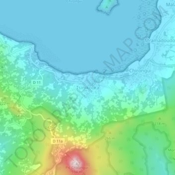
Name: Tsimkoura topographic map, elevation, terrain.
Location: Tsimkoura, Chirongui, Mayotte, 97620, France (-12.95939 45.11689 -12.91939 45.15689)
Average elevation: 305 ft
Minimum elevation: 0 ft
Maximum elevation: 1,654 ft
Make a donation
Gear up for your next adventure:
As an Amazon Associate, this site earns from qualifying purchases at no extra cost to you.
Other topographic maps
Click on a map to view its topography, its elevation and its terrain.
Mtsamboro
The village of Mtsamboro lies on the northwest coast of the island along National Road 1. To the northeast is the village of Mtsahara and to the southwest is Mtsangadoua. Two small peninsulas jut out in the village area, the larger of which lies roughly a mile north of the village centre and separates the main…
Average elevation: 157 ft
Make a donation
Gear up for your next adventure:
As an Amazon Associate, this site earns from qualifying purchases at no extra cost to you.
Make a donation
Gear up for your next adventure:
As an Amazon Associate, this site earns from qualifying purchases at no extra cost to you.
Make a donation
Gear up for your next adventure:
As an Amazon Associate, this site earns from qualifying purchases at no extra cost to you.
Bandraboua (canton de Mtsamboro)
France > Mayotte > Bandraboua > M'Tsangamboua
Average elevation: 335 ft