
Bahama topographic map
Click on the map to display elevation.
About this map
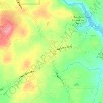
Name: Bahama topographic map, elevation, terrain.
Location: Bahama, Durham County, North Carolina, United States (36.16305 -78.88096 36.17149 -78.87143)
Average elevation: 486 ft
Minimum elevation: 328 ft
Maximum elevation: 663 ft
Durham County trails, hiking, mountain biking, running and outdoor activities
Other topographic maps
Click on a map to view its topography, its elevation and its terrain.
Durham
United States > North Carolina > Durham County
Durham is located in the east-central part of the Piedmont region at 35°59′19″N 78°54′26″W / 35.98861°N 78.90722°W / 35.98861; -78.90722 (35.988644, −78.907167). Like much of the region, its topography is generally flat with some rolling hills.
Average elevation: 384 ft
Durham
United States > North Carolina > Durham County
Durham is located in the east–central part of the Piedmont region at 35°59′19″N 78°54′26″W / 35.98861°N 78.90722°W / 35.98861; -78.90722 (35.99, -78.9). Like much of the region, its topography is generally flat with some rolling hills.
Average elevation: 384 ft
Durham
United States > North Carolina > Durham County
Durham is located in the east-central part of the Piedmont region at 35°59′19″N 78°54′26″W / 35.98861°N 78.90722°W / 35.98861; -78.90722 (35.988644, −78.907167). Like much of the region, its topography is generally flat with some rolling hills.
Average elevation: 384 ft
Durham
United States > North Carolina > Durham County
Durham is located in the east–central part of the Piedmont region at 35°59′19″N 78°54′26″W / 35.98861°N 78.90722°W / 35.98861; -78.90722 (35.99, -78.9). Like much of the region, its topography is generally flat with some rolling hills.
Average elevation: 384 ft