
District of Pezinok topographic map
Interactive map
Click on the map to display elevation.
About this map
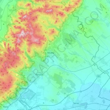
Name: District of Pezinok topographic map, elevation, terrain.
Location: District of Pezinok, Region of Bratislava, Slovakia (48.20387 17.13422 48.45631 17.47752)
Average elevation: 860 ft
Minimum elevation: 387 ft
Maximum elevation: 2,448 ft
Other topographic maps
Click on a map to view its topography, its elevation and its terrain.
Bratislava
Slovakia > Region of Bratislava > District of Bratislava I > Old Town
The Carpathian mountain range begins in city territory with the Little Carpathians (Malé Karpaty). The Záhorie and Danubian lowlands stretch into Bratislava. The city's lowest point is at the Danube's surface at 126 metres (413 ft) above mean sea level, and the highest point is Devínska Kobyla at 514 metres…
Average elevation: 574 ft
Danube
Slovakia > Region of Bratislava > District of Senec > Bratislava > Čunovo
Average elevation: 410 ft
Veľkobielske jazero "Šutrovka"
Slovakia > Region of Bratislava > District of Senec > Veľký Biel
Average elevation: 417 ft
Častá
Slovakia > Region of Bratislava > District of Pezinok
The village lies at an altitude of 245 meters and covers an area of 35.24 km². It has population of 2,078 people.
Average elevation: 860 ft
Devín Castle
Slovakia > Region of Bratislava > Bratislava > District of Bratislava IV > Devín
The cliff (elevation 212 meters) is an ideal place for a fort due to its position at the confluence of the Danube and Morava rivers. The fort watches over an important trade route along the Danube as well as one branch of the Amber Road.
Average elevation: 574 ft
Old Town
Slovakia > Region of Bratislava > District of Bratislava I > Old Town > Old Town
Average elevation: 522 ft
Ružinov
Slovakia > Region of Bratislava > District of Bratislava II > Ružinov > Ružinov
Average elevation: 469 ft