
Make a donation
Gear up for your next adventure:
As an Amazon Associate, this site earns from qualifying purchases at no extra cost to you.
Kamzík topographic map
Click on the map to display elevation.
Make a donation
Gear up for your next adventure:
As an Amazon Associate, this site earns from qualifying purchases at no extra cost to you.
About this map
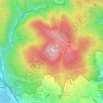
Name: Kamzík topographic map, elevation, terrain.
Location: Kamzík, Region of Bratislava, Bratislava, 83007, Slovakia (48.18180 17.09332 48.18190 17.09342)
Average elevation: 1,001 ft
Minimum elevation: 568 ft
Maximum elevation: 1,440 ft
Make a donation
Gear up for your next adventure:
As an Amazon Associate, this site earns from qualifying purchases at no extra cost to you.
Other topographic maps
Click on a map to view its topography, its elevation and its terrain.
Marianka
Slovakia > Region of Bratislava > District of Malacky > Bratislava
The municipality lies at an altitude of 230 metres (750 ft) and covers an area of 3.22 km2 (1.24 sq mi) (2025).
Average elevation: 817 ft
Bratislava
Slovakia > Region of Bratislava
The Carpathian mountain range begins in city territory with the Little Carpathians (Malé Karpaty). The Záhorie and Danubian lowlands stretch into Bratislava. The city's lowest point is at the Danube's surface at 126 metres (413 ft) above mean sea level, and the highest point is Devínska Kobyla at 514 metres…
Average elevation: 551 ft
Stupava
Slovakia > Region of Bratislava
The town is located in the Záhorie lowland, under the Little Carpathians, around 15 km (9 mi) north of Bratislava at an altitude of 182 metres. It has 15, 095 inhabitants as of 2021 and has a land area of 67.17 km2 (26 sq mi). Apart from the core part of the city, Mást (German: Maaßt, Hungarian: Mászt),…
Average elevation: 778 ft
Bratislava
Slovakia > Region of Bratislava
The Carpathian mountain range begins in city territory with the Little Carpathians (Malé Karpaty). The Záhorie and Danubian lowlands stretch into Bratislava. The city's lowest point is at the Danube's surface at 126 metres (413 ft) above mean sea level, and the highest point is Devínska Kobyla at 514 metres…
Average elevation: 564 ft
Make a donation
Gear up for your next adventure:
As an Amazon Associate, this site earns from qualifying purchases at no extra cost to you.
Bratislava
Slovakia > Region of Bratislava
The Carpathian mountain range begins in city territory with the Little Carpathians (Malé Karpaty). The Záhorie and Danubian lowlands stretch into Bratislava. The city's lowest point is at the Danube's surface at 126 metres (413 ft) above mean sea level, and the highest point is Devínska Kobyla at 514 metres…
Average elevation: 564 ft
Bratislava
Slovakia > Region of Bratislava
The Carpathian mountain range begins in city territory with the Little Carpathians (Malé Karpaty). The Záhorie and Danubian lowlands stretch into Bratislava. The city's lowest point is at the Danube's surface at 126 metres (413 ft) above mean sea level, and the highest point is Devínska Kobyla at 514 metres…
Average elevation: 554 ft
Make a donation
Gear up for your next adventure:
As an Amazon Associate, this site earns from qualifying purchases at no extra cost to you.
Bernolákovo
Slovakia > Region of Bratislava > District of Senec
The municipality lies at an altitude of 141 metres (463 ft) and covers an area of 28.43 km2 (10.98 sq mi) (2024).
Average elevation: 436 ft
Devínska Nová Ves
Slovakia > Region of Bratislava > Bratislava
The municipality lies at an altitude of 159 metres (522 ft) and covers an area of 24.21 km2 (9.35 sq mi) (2024).
Average elevation: 551 ft
Senec
Slovakia > Region of Bratislava > District of Senec
The municipality lies at an altitude of 148 metres (486 ft) and covers an area of 38.71 km2 (14.95 sq mi) (2024).
Average elevation: 453 ft
Svätý Jur
Slovakia > Region of Bratislava > District of Pezinok
The municipality lies at an altitude of 147 metres (482 ft) and covers an area of 39.86 km2 (15.39 sq mi) (2024).
Average elevation: 748 ft
Make a donation
Gear up for your next adventure:
As an Amazon Associate, this site earns from qualifying purchases at no extra cost to you.
Pezinok
Slovakia > Region of Bratislava > District of Pezinok
The municipality lies at an altitude of 151 metres (495 ft) and covers an area of 72.75 km2 (28.09 sq mi) (2024). It is located in the Danubian Lowland at the foothills of the Little Carpathians, around 20 km (12.43 mi) north-east of Bratislava. Another major city, Trnava, is located around 25 km (15.53 mi) to…
Average elevation: 984 ft
Bratislava
Slovakia > Region of Bratislava
The Carpathian mountain range begins in city territory with the Little Carpathians (Malé Karpaty). The Záhorie and Danubian lowlands stretch into Bratislava. The city's lowest point is at the Danube's surface at 126 metres (413 ft) above mean sea level, and the highest point is Devínska Kobyla at 514 metres…
Average elevation: 554 ft
Bratislava
Slovakia > Region of Bratislava
The Carpathian mountain range begins in city territory with the Little Carpathians (Malé Karpaty). The Záhorie and Danubian lowlands stretch into Bratislava. The city's lowest point is at the Danube's surface at 126 metres (413 ft) above mean sea level, and the highest point is Devínska Kobyla at 514 metres…
Average elevation: 564 ft
Make a donation
Gear up for your next adventure:
As an Amazon Associate, this site earns from qualifying purchases at no extra cost to you.
Bratislava
Slovakia > Region of Bratislava
The Carpathian mountain range begins in city territory with the Little Carpathians (Malé Karpaty). The Záhorie and Danubian lowlands stretch into Bratislava. The city's lowest point is at the Danube's surface at 126 metres (413 ft) above mean sea level, and the highest point is Devínska Kobyla at 514 metres…
Average elevation: 554 ft
Make a donation
Gear up for your next adventure:
As an Amazon Associate, this site earns from qualifying purchases at no extra cost to you.
Bratislava
Slovakia > Region of Bratislava
The Carpathian mountain range begins in city territory with the Little Carpathians (Malé Karpaty). The Záhorie and Danubian lowlands stretch into Bratislava. The city's lowest point is at the Danube's surface at 126 metres (413 ft) above mean sea level, and the highest point is Devínska Kobyla at 514 metres…
Average elevation: 551 ft
Tureň
Slovakia > Region of Bratislava > District of Senec
The municipality lies at an altitude of 126 metres (413 ft) and covers an area of 5.303 km2 (2.047 sq mi).
Average elevation: 413 ft
Danube
Slovakia > Region of Bratislava > District of Senec > Bratislava > Čunovo
Average elevation: 410 ft
Make a donation
Gear up for your next adventure:
As an Amazon Associate, this site earns from qualifying purchases at no extra cost to you.
Bratislava
Slovakia > Region of Bratislava
The Carpathian mountain range begins in city territory with the Little Carpathians (Malé Karpaty). The Záhorie and Danubian lowlands stretch into Bratislava. The city's lowest point is at the Danube's surface at 126 metres (413 ft) above mean sea level, and the highest point is Devínska Kobyla at 514 metres…
Average elevation: 564 ft
Make a donation
Gear up for your next adventure:
As an Amazon Associate, this site earns from qualifying purchases at no extra cost to you.
Pezinok
Slovakia > Region of Bratislava > District of Pezinok
Pezinok lies at an altitude of 152 metres (499 ft) above sea level and covers an area of 72.555 square kilometres (28.0 sq mi). It is located in the Danubian Lowland at the foothills of the Little Carpathians, around 20 km (12.43 mi) north-east of Bratislava. Another major city, Trnava, is located around 25 km…
Average elevation: 984 ft
Bratislava
Slovakia > Region of Bratislava
The Carpathian mountain range begins in city territory with the Little Carpathians (Malé Karpaty). The Záhorie and Danubian lowlands stretch into Bratislava. The city's lowest point is at the Danube's surface at 126 metres (413 ft) above mean sea level, and the highest point is Devínska Kobyla at 514 metres…
Average elevation: 564 ft
Veľkobielske jazero "Šutrovka"
Slovakia > Region of Bratislava > District of Senec > Veľký Biel
Average elevation: 417 ft
Make a donation
Gear up for your next adventure:
As an Amazon Associate, this site earns from qualifying purchases at no extra cost to you.
Veľký Biel
Slovakia > Region of Bratislava > District of Senec
The municipality lies at an altitude of 131 metres and covers an area of 10.161 km². It has a population of 2303 people.
Average elevation: 427 ft
Vojenský obvod Záhorie
Slovakia > Region of Bratislava > District of Malacky
Average elevation: 869 ft
Make a donation
Gear up for your next adventure:
As an Amazon Associate, this site earns from qualifying purchases at no extra cost to you.
Devín Castle
Slovakia > Region of Bratislava > Bratislava > District of Bratislava IV > Devín
The cliff (elevation 212 meters) is an ideal place for a fort due to its position at the confluence of the Danube and Morava rivers. The fort watches over an important trade route along the Danube as well as one branch of the Amber Road.
Average elevation: 574 ft
Make a donation
Gear up for your next adventure:
As an Amazon Associate, this site earns from qualifying purchases at no extra cost to you.
Bernolákovo
Slovakia > Region of Bratislava > District of Senec > Bernolákovo
Average elevation: 436 ft
Častá
Slovakia > Region of Bratislava > District of Pezinok
The village lies at an altitude of 245 meters and covers an area of 35.24 km². It has population of 2,078 people.
Average elevation: 860 ft