
Make a donation
Gear up for your next adventure:
As an Amazon Associate, this site earns from qualifying purchases at no extra cost to you.
Al-Qardaha topographic map
Click on the map to display elevation.
Make a donation
Gear up for your next adventure:
As an Amazon Associate, this site earns from qualifying purchases at no extra cost to you.
Al-Qardaha
Qardaha has a hot-summer Mediterranean climate (Köppen climate classification: Csa). Qardaha is in a mountainous area, but its altitude is only between 350 and 500 meters. It is in a beautiful forested area. Qardaha has much rainfall. The average high temperature in July is 29 °C, and in January is 7 °C. There is nearly 828 mm of rainfall annually and three days of snow in January. The climate and nature in Qerdaha favour agriculture, and there are apple and orange plantations and tobacco farms.
Make a donation
Gear up for your next adventure:
As an Amazon Associate, this site earns from qualifying purchases at no extra cost to you.
About this map
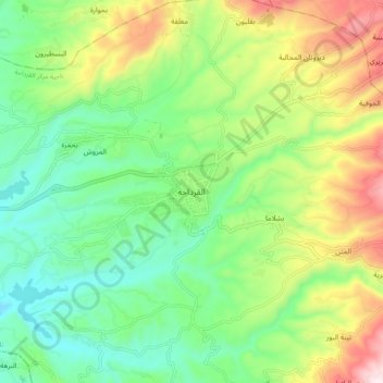
Name: Al-Qardaha topographic map, elevation, terrain.
Average elevation: 1,099 ft
Minimum elevation: 325 ft
Maximum elevation: 2,533 ft
Make a donation
Gear up for your next adventure:
As an Amazon Associate, this site earns from qualifying purchases at no extra cost to you.
Other topographic maps
Click on a map to view its topography, its elevation and its terrain.
Citadel of Salah Ed-Din (Saladin Castle)
Syria > Lattakia Governorate > Daryus
Average elevation: 1,339 ft
Make a donation
Gear up for your next adventure:
As an Amazon Associate, this site earns from qualifying purchases at no extra cost to you.