
Hopewell Parish topographic map
Interactive map
Click on the map to display elevation.
About this map
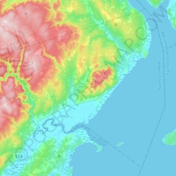
Name: Hopewell Parish topographic map, elevation, terrain.
Location: Hopewell Parish, Albert County, New Brunswick, Canada (45.69830 -64.81696 45.86910 -64.54696)
Average elevation: 315 ft
Minimum elevation: -3 ft
Maximum elevation: 1,286 ft
Other topographic maps
Click on a map to view its topography, its elevation and its terrain.
Shepody Mountain
Canada > New Brunswick > Hopewell Parish
Shepody Mountain, Hopewell Parish, Albert County, New Brunswick, E4H 3P2, Canada
Average elevation: 577 ft
Riverside-Albert
Canada > New Brunswick > Hopewell Parish
Riverside-Albert, Hopewell Parish, Albert County, New Brunswick, E4H 4C1, Canada
Average elevation: 115 ft