
Thank you for supporting this site ❤️
Make a donation
Make a donation
Gear up for your next adventure:
As an Amazon Associate, this site earns from qualifying purchases at no extra cost to you.
Kronberg topographic map
Click on the map to display elevation.
Thank you for supporting this site ❤️
Make a donation
Make a donation
Gear up for your next adventure:
As an Amazon Associate, this site earns from qualifying purchases at no extra cost to you.
About this map
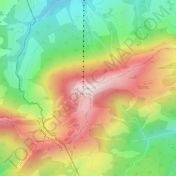
Name: Kronberg topographic map, elevation, terrain.
Location: Kronberg, Gonten, Appenzell Innerrhoden, 9108, Schweiz (47.29156 9.32888 47.29166 9.32898)
Average elevation: 4,239 ft
Minimum elevation: 3,278 ft
Maximum elevation: 5,381 ft
Thank you for supporting this site ❤️
Make a donation
Make a donation
Gear up for your next adventure:
As an Amazon Associate, this site earns from qualifying purchases at no extra cost to you.