
Thank you for supporting this site ❤️
Make a donation
Make a donation
Gear up for your next adventure:
As an Amazon Associate, this site earns from qualifying purchases at no extra cost to you.
Buitenland topographic map
Click on the map to display elevation.
Thank you for supporting this site ❤️
Make a donation
Make a donation
Gear up for your next adventure:
As an Amazon Associate, this site earns from qualifying purchases at no extra cost to you.
About this map
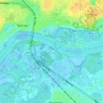
Name: Buitenland topographic map, elevation, terrain.
Location: Buitenland, Bornem, Malines, Anvers, Flandre, 2880, Belgique (51.09523 4.21144 51.13523 4.25144)
Average elevation: 20 ft
Minimum elevation: -13 ft
Maximum elevation: 89 ft
Thank you for supporting this site ❤️
Make a donation
Make a donation
Gear up for your next adventure:
As an Amazon Associate, this site earns from qualifying purchases at no extra cost to you.