
Make a donation
Gear up for your next adventure:
As an Amazon Associate, this site earns from qualifying purchases at no extra cost to you.
Marialinden topographic map
Click on the map to display elevation.
Make a donation
Gear up for your next adventure:
As an Amazon Associate, this site earns from qualifying purchases at no extra cost to you.
Marialinden
Der tatsächliche, historisch gesicherte Gründungsgrund der Kirche war jedoch ein anderer: An der Stelle der heutigen Sakristei entstand an der Wegkreuzung des Wegs von Bernsau über Höhe nach Meegen und dem Handelsweg Köln–Siegen (Brüderstraße), eine Jagdkapelle der Grafen von Bernsau. Der „Bernsauer Jagdweg“ zeugt davon noch heute. Später siedelten sich Gasthäuser an.
Make a donation
Gear up for your next adventure:
As an Amazon Associate, this site earns from qualifying purchases at no extra cost to you.
About this map
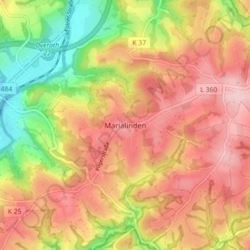
Name: Marialinden topographic map, elevation, terrain.
Average elevation: 640 ft
Minimum elevation: 285 ft
Maximum elevation: 899 ft
Make a donation
Gear up for your next adventure:
As an Amazon Associate, this site earns from qualifying purchases at no extra cost to you.
Other topographic maps
Click on a map to view its topography, its elevation and its terrain.
Breidenassel
Deutschland > Nordrhein-Westfalen > Rheinisch-Bergischer Kreis > Overath
Average elevation: 597 ft