Geolocate

Mifflinburg topographic map

Click on the map to display elevation.

About this map

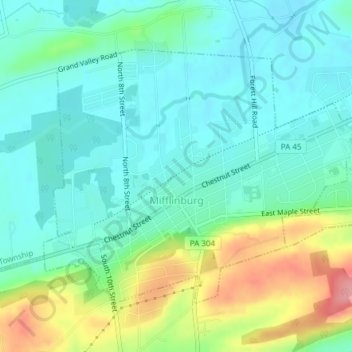
Name: Mifflinburg topographic map, elevation, terrain.

Location: Mifflinburg, Union County, Pennsylvania, 17844, United States (40.90915 -77.06211 40.92984 -77.02418)

Average elevation: 623 ft

Minimum elevation: 525 ft

Maximum elevation: 876 ft

Union County trails, hiking, mountain biking, running and outdoor activities

Other topographic maps

Click on a map to view its topography, its elevation and its terrain.

Lewisburg

United States > Pennsylvania > Union County > Lewisburg

Average elevation: 515 ft

College Park

United States > Pennsylvania > Union County

Average elevation: 499 ft

Gear up for your next adventure:

🛠️Outdoor Gear Repair Kit - Essential tools to fix gear on the trail
🔥Fast-Boil Camping Stoves - Efficient cooking systems for quick trail meals
🛡️Insect Repellent - Protection against bugs during outdoor activities
🎒Waterproof Dry Bags - Keep your electronics and maps dry inside your pack
🛰️Satellite Messengers - Emergency SOS and two-way messaging for off-grid adventures

As an Amazon Associate, this site earns from qualifying purchases at no extra cost to you.