
Thank you for supporting this site ❤️
Make a donation
Make a donation
Gear up for your next adventure:
As an Amazon Associate, this site earns from qualifying purchases at no extra cost to you.
Indre-et-Loire topographic map
Click on the map to display elevation.
Thank you for supporting this site ❤️
Make a donation
Make a donation
Gear up for your next adventure:
As an Amazon Associate, this site earns from qualifying purchases at no extra cost to you.
About this map
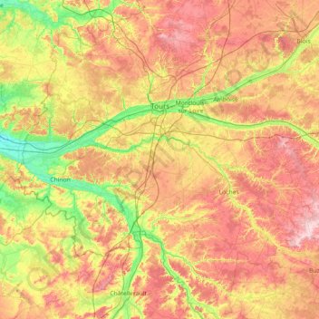
Name: Indre-et-Loire topographic map, elevation, terrain.
Location: Indre-et-Loire, Centre-Val de Loire, Metropolitan France, France (46.73666 0.05276 47.70979 1.36594)
Average elevation: 322 ft
Minimum elevation: 79 ft
Maximum elevation: 650 ft
Thank you for supporting this site ❤️
Make a donation
Make a donation
Gear up for your next adventure:
As an Amazon Associate, this site earns from qualifying purchases at no extra cost to you.
Other topographic maps
Click on a map to view its topography, its elevation and its terrain.