
Make a donation
Gear up for your next adventure:
As an Amazon Associate, this site earns from qualifying purchases at no extra cost to you.
Buslavín topographic map
Click on the map to display elevation.
Make a donation
Gear up for your next adventure:
As an Amazon Associate, this site earns from qualifying purchases at no extra cost to you.
About this map
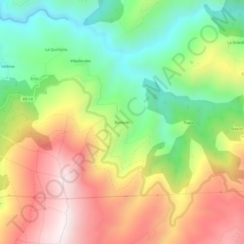
Name: Buslavín topographic map, elevation, terrain.
Location: Buslavín, Allande, Asturias, España (43.23591 -6.82044 43.27591 -6.78044)
Average elevation: 1,850 ft
Minimum elevation: 384 ft
Maximum elevation: 3,566 ft
Make a donation
Gear up for your next adventure:
As an Amazon Associate, this site earns from qualifying purchases at no extra cost to you.
Other topographic maps
Click on a map to view its topography, its elevation and its terrain.
Villar de Sapos
La aldea de Villar de Sapos se sitúa a 560 metros de altitud, en la margen izquierda del río Arganza, en la ladera sur de la sierra La Pila. Se encuentra a 18 km de Pola de Allande y tiene una población de 7 habitantes (INE 2011). Su pequeña iglesia parroquial, dedicada a Santiago, tiene en su interior un…
Average elevation: 2,067 ft