
Make a donation
Gear up for your next adventure:
As an Amazon Associate, this site earns from qualifying purchases at no extra cost to you.
Kumphawapi topographic map
Click on the map to display elevation.
Make a donation
Gear up for your next adventure:
As an Amazon Associate, this site earns from qualifying purchases at no extra cost to you.
About this map
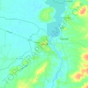
Name: Kumphawapi topographic map, elevation, terrain.
Location: Kumphawapi, Wiang Kham, Udon Thani Province, Thailand (17.07002 102.97533 17.15002 103.05533)
Average elevation: 577 ft
Minimum elevation: 545 ft
Maximum elevation: 669 ft
Make a donation
Gear up for your next adventure:
As an Amazon Associate, this site earns from qualifying purchases at no extra cost to you.
Other topographic maps
Click on a map to view its topography, its elevation and its terrain.
Ko Pha Ngan
Due to its topography, the population hugs the coastline. The mountainous interior is generally inaccessible. More than half the island is designated as a national park and Ko Pha-ngan has more than 80 km2 (31 sq mi) of relatively unspoiled rain forest with diverse flora and fauna.
Average elevation: 276 ft
Make a donation
Gear up for your next adventure:
As an Amazon Associate, this site earns from qualifying purchases at no extra cost to you.
Make a donation
Gear up for your next adventure:
As an Amazon Associate, this site earns from qualifying purchases at no extra cost to you.
Chiang Mai Province
Thailand > Chiang Mai Province
Chiang Mai Province is about 685 km (426 mi) from Bangkok in the Mae Ping River basin and is on average at 300 m (1,000 ft) elevation. Surrounded by the mountain ranges of the Thai highlands, it covers an area of approximately 20,107 km2 (8,000 sq mi). The mountains of the Daen Lao Range…
Average elevation: 2,129 ft
Make a donation
Gear up for your next adventure:
As an Amazon Associate, this site earns from qualifying purchases at no extra cost to you.
Maha Phram Subdistrict Municipality
Thailand > Phra Nakhon Si Ayutthaya Province > Bang Ban District
Average elevation: 16 ft
Make a donation
Gear up for your next adventure:
As an Amazon Associate, this site earns from qualifying purchases at no extra cost to you.
Mae Hong Son Province
The Daen Lao Range, in the northernmost portion of the province, marks the northern boundary between Thailand and Burma, while the Dawna Range in the west serves as the boundary between Thailand and Burma. The Thanon Thongchai Range in the east of the province serves as the boundary between the provinces of…
Average elevation: 2,310 ft
Nong Prue Subdistrict
Thailand > Samut Prakan Province > Bang Phli District > Nong Prue Subdistrict
Average elevation: 10 ft
Make a donation
Gear up for your next adventure:
As an Amazon Associate, this site earns from qualifying purchases at no extra cost to you.
Racha Thewa Subdistrict
Thailand > Samut Prakan Province > Racha Thewa Subdistrict Administrative Organization
Average elevation: 10 ft