
Make a donation
Gear up for your next adventure:
As an Amazon Associate, this site earns from qualifying purchases at no extra cost to you.
Wildflecken topographic map
Click on the map to display elevation.
Make a donation
Gear up for your next adventure:
As an Amazon Associate, this site earns from qualifying purchases at no extra cost to you.
Wildflecken
Dubbed "The Top of the Rock" by American troops, the small post was among the most feared and disliked of all training areas due to high altitude and extreme weather conditions. It featured ranges for tanks, artillery and basic training facilities. Additionally, it was one of only a few training sites allowed by the German government to utilize CS gas in training.
Make a donation
Gear up for your next adventure:
As an Amazon Associate, this site earns from qualifying purchases at no extra cost to you.
About this map
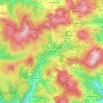
Name: Wildflecken topographic map, elevation, terrain.
Location: Wildflecken, Landkreis Bad Kissingen, Bavaria, Germany (50.33132 9.78223 50.42253 9.95592)
Average elevation: 2,123 ft
Minimum elevation: 1,224 ft
Maximum elevation: 3,054 ft
Make a donation
Gear up for your next adventure:
As an Amazon Associate, this site earns from qualifying purchases at no extra cost to you.