Geolocate

Monte Mario topographic map

Click on the map to display elevation.

About this map

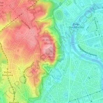
Name: Monte Mario topographic map, elevation, terrain.

Location: Monte Mario, Rome, Roma Capitale, Lazio, 00136, Italy (41.92435 12.45208 41.92445 12.45218)

Average elevation: 213 ft

Minimum elevation: 23 ft

Maximum elevation: 479 ft

Other topographic maps

Click on a map to view its topography, its elevation and its terrain.

Tiber Island

Italy > Lazio > Roma Capitale > Rome

Average elevation: 125 ft

Parco del Ninfeo

Italy > Lazio > Roma Capitale > Rome

Average elevation: 89 ft

Gear up for your next adventure:

📡Handheld GPS Device - Reliable handheld GPS for outdoor navigation
🌄Hiking Binoculars - Compact binoculars for scenic views and trail spotting
🦶Carbon Trekking Poles - Reduce knee impact on steep descents with ultra-light poles
🥤Water Filter Bottle - All‑in‑one filter bottle for safe hydration
🧭Outdoor Navigation Book - Learn advanced navigation skills

As an Amazon Associate, this site earns from qualifying purchases at no extra cost to you.