Geolocate

Ciburial topographic map

Click on the map to display elevation.

About this map

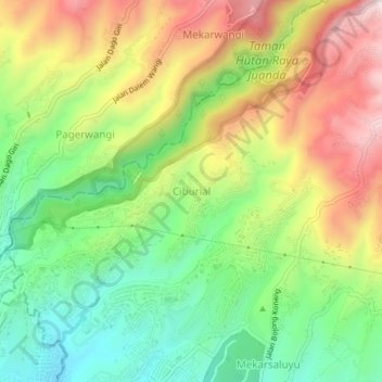
Name: Ciburial topographic map, elevation, terrain.

Location: Ciburial, Bandung, West Java, Java, 40198, Indonesia (-6.87518 107.62393 -6.83518 107.66393)

Average elevation: 3,301 ft

Minimum elevation: 2,526 ft

Maximum elevation: 4,301 ft

Gear up for your next adventure:

🔌USB Car Charger - Car charger for on‑the‑go power needs
🔭Compact Binoculars - HD vision for scouting terrain and identifying distant landmarks
📖Nature Tracking Books - Learn to track wildlife and terrain
🏫Relief Map Kits - Hands-on tools for teaching landforms and elevation
🦟Ultrasonic Repellers - Create a bug-free zone at your camp or rest stop

As an Amazon Associate, this site earns from qualifying purchases at no extra cost to you.