Geolocate

Martignano topographic map

Click on the map to display elevation.

About this map

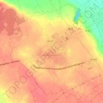
Name: Martignano topographic map, elevation, terrain.

Location: Martignano, Lecce, Apulia, Italy (40.22479 18.23929 40.25194 18.27734)

Average elevation: 285 ft

Minimum elevation: 144 ft

Maximum elevation: 328 ft

Other topographic maps

Click on a map to view its topography, its elevation and its terrain.

Porto Miggiano

Italy > Apulia > Lecce > Santa Cesarea Terme

Average elevation: 157 ft

Torre Rinalda

Italy > Apulia > Lecce > Lecce

Average elevation: 3 ft

Santa Maria di Leuca

Italy > Apulia > Lecce

Average elevation: 135 ft

Giorgilorio

Italy > Apulia > Lecce > Surbo > Giorgilorio

Average elevation: 141 ft

Porto Badisco

Italy > Apulia > Lecce > Otranto

Average elevation: 125 ft

Gear up for your next adventure:

🥾Hiking Shoes - Durable and comfortable shoes for trail hiking
📦Gear Storage Bags - Organize and protect outdoor equipment
🥇GPS Hiking Watch - Multi‑sport GPS watch with navigation and trail tracking
🍳Camping Cook Set - Complete cookware for outdoor meals
Camping Coffee Makers - Enjoy premium coffee at the summit or campsite

As an Amazon Associate, this site earns from qualifying purchases at no extra cost to you.