
Make a donation
Gear up for your next adventure:
As an Amazon Associate, this site earns from qualifying purchases at no extra cost to you.
Werkel topographic map
Click on the map to display elevation.
Make a donation
Gear up for your next adventure:
As an Amazon Associate, this site earns from qualifying purchases at no extra cost to you.
About this map
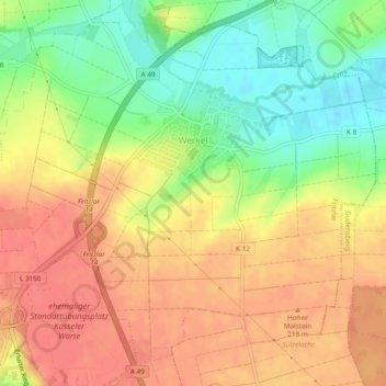
Name: Werkel topographic map, elevation, terrain.
Location: Werkel, Fritzlar, Schwalm-Eder-Kreis, Hessen, Deutschland (51.13727 9.28394 51.16379 9.33141)
Average elevation: 663 ft
Minimum elevation: 551 ft
Maximum elevation: 741 ft
Make a donation
Gear up for your next adventure:
As an Amazon Associate, this site earns from qualifying purchases at no extra cost to you.
Other topographic maps
Click on a map to view its topography, its elevation and its terrain.
Gudensberg
Deutschland > Hessen > Schwalm-Eder-Kreis
An einer Wegkreuzung von Gudensberg nach Kassel nördlich von Gudensberg steht das Kasseler Kreuz, ein gotisches Steinkreuz aus dem 14. Jahrhundert. Es handelt sich dabei vermutlich um ein Sühnekreuz eines unbekannten Steinmetzes. Das 1,2 m hohe und 0,6 m breite Kreuz wurde aus unbekanntem Anlass gesetzt.…
Average elevation: 705 ft