
Thank you for supporting this site ❤️
Make a donation
Make a donation
Gear up for your next adventure:
As an Amazon Associate, this site earns from qualifying purchases at no extra cost to you.
استاد topographic map
Click on the map to display elevation.
Thank you for supporting this site ❤️
Make a donation
Make a donation
Gear up for your next adventure:
As an Amazon Associate, this site earns from qualifying purchases at no extra cost to you.
About this map
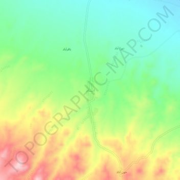
Name: استاد topographic map, elevation, terrain.
Location: استاد, بخش کاخک, شهرستان گناباد, Razavikhorasan, Iran (34.10889 58.75500 34.14889 58.79500)
Average elevation: 4,767 ft
Minimum elevation: 4,455 ft
Maximum elevation: 5,243 ft
Thank you for supporting this site ❤️
Make a donation
Make a donation
Gear up for your next adventure:
As an Amazon Associate, this site earns from qualifying purchases at no extra cost to you.