
Make a donation
Gear up for your next adventure:
As an Amazon Associate, this site earns from qualifying purchases at no extra cost to you.
Sofia topographic map
Click on the map to display elevation.
Make a donation
Gear up for your next adventure:
As an Amazon Associate, this site earns from qualifying purchases at no extra cost to you.
About this map
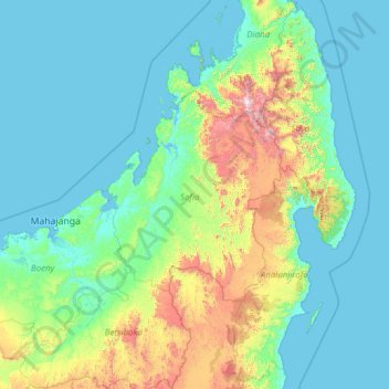
Name: Sofia topographic map, elevation, terrain.
Location: Sofia, Province de Mahajanga, Madagascar (-17.85384 45.65622 -12.65384 50.85622)
Average elevation: 856 ft
Minimum elevation: -3 ft
Maximum elevation: 9,019 ft
Make a donation
Gear up for your next adventure:
As an Amazon Associate, this site earns from qualifying purchases at no extra cost to you.
Other topographic maps
Click on a map to view its topography, its elevation and its terrain.
Make a donation
Gear up for your next adventure:
As an Amazon Associate, this site earns from qualifying purchases at no extra cost to you.
Nosy Komba
Madagascar > Diana Region > Ampangorina
French settler-colonial efforts on Nosy Be were persistently hampered by outbreaks of diseases such as malaria, cholera, and smallpox. To remedy this, a convalescence for French settlers was built on the adjacent Nosy Komba in 1841, immediately following the French annexation of the region, with an upgraded…
Average elevation: 436 ft
Make a donation
Gear up for your next adventure:
As an Amazon Associate, this site earns from qualifying purchases at no extra cost to you.
Make a donation
Gear up for your next adventure:
As an Amazon Associate, this site earns from qualifying purchases at no extra cost to you.
Make a donation
Gear up for your next adventure:
As an Amazon Associate, this site earns from qualifying purchases at no extra cost to you.
Make a donation
Gear up for your next adventure:
As an Amazon Associate, this site earns from qualifying purchases at no extra cost to you.
Marojejy National Park
Madagascar > Antsiranana Province > District de Sambava
Marojejy National Park (/məˈroʊdʒɛdʒiː/) is a national park in the Sava region of northeastern Madagascar. It covers 55,500 ha (214 sq mi) and is centered on the Marojejy Massif, a mountain chain that rises to an elevation of 2,132 m (6,995 ft). Access to the area around the massif was restricted to…
Average elevation: 2,215 ft
Bongolava
The region is situated in central-western Madagascar. It is bordered by Betsiboka, Melaky, Menabe, Vakinankaratra, Itasy and Analamanga. The altitude ranges from 800 m (2,600 ft) to 1,500 m (4,900 ft).
Average elevation: 3,238 ft
Make a donation
Gear up for your next adventure:
As an Amazon Associate, this site earns from qualifying purchases at no extra cost to you.
Make a donation
Gear up for your next adventure:
As an Amazon Associate, this site earns from qualifying purchases at no extra cost to you.
Fianarantsoa
Madagascar > Haute Matsiatra > District de Fianarantsoa
It is at an average altitude of 1,200 metres (3,900 ft), and has a population of 191,766.
Average elevation: 3,845 ft
Make a donation
Gear up for your next adventure:
As an Amazon Associate, this site earns from qualifying purchases at no extra cost to you.
Make a donation
Gear up for your next adventure:
As an Amazon Associate, this site earns from qualifying purchases at no extra cost to you.
Réserve Naturelle Intégrale des Tsingy de Bemaraha
Madagascar > Melaky > Antsalova
Average elevation: 338 ft
Make a donation
Gear up for your next adventure:
As an Amazon Associate, this site earns from qualifying purchases at no extra cost to you.
Make a donation
Gear up for your next adventure:
As an Amazon Associate, this site earns from qualifying purchases at no extra cost to you.
Fianarantsoa
Madagascar > Haute Matsiatra > District de Fianarantsoa
It is at an average altitude of 1,200 metres (3,900 ft), and has a population of 191,766.
Average elevation: 3,845 ft
Make a donation
Gear up for your next adventure:
As an Amazon Associate, this site earns from qualifying purchases at no extra cost to you.
Madagascar
Madagascar > Province d’Antananarivo
Madagascar can be divided into five general geographical regions: the east coast, the Tsaratanana Massif, the Central Highlands, the west coast, and the southwest. The highest elevations parallel the east coast.
Average elevation: 472 ft
Make a donation
Gear up for your next adventure:
As an Amazon Associate, this site earns from qualifying purchases at no extra cost to you.
Make a donation
Gear up for your next adventure:
As an Amazon Associate, this site earns from qualifying purchases at no extra cost to you.
Make a donation
Gear up for your next adventure:
As an Amazon Associate, this site earns from qualifying purchases at no extra cost to you.