
Beausoleil Island topographic map
Interactive map
Click on the map to display elevation.
About this map
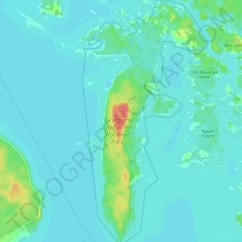
Name: Beausoleil Island topographic map, elevation, terrain.
Average elevation: 591 ft
Minimum elevation: 568 ft
Maximum elevation: 728 ft
Other topographic maps
Click on a map to view its topography, its elevation and its terrain.
Six Mile Lake Provincial Park
Canada > Ontario > Georgian Bay
Six Mile Lake Provincial Park, Georgian Bay, District Municipality of Muskoka, Muskoka District, Ontario, Canada
Average elevation: 650 ft
Georgian Bay Islands National Park
Canada > Ontario > Georgian Bay
Georgian Bay Islands National Park, Georgian Bay, District Municipality of Muskoka, Muskoka District, Ontario, Canada
Average elevation: 587 ft
Musquash River
Canada > Ontario > Georgian Bay
Musquash River, Georgian Bay, District Municipality of Muskoka, Muskoka District, Ontario, Canada
Average elevation: 692 ft
Fairy Lake
Canada > Ontario > Georgian Bay
Fairy Lake, nice path, Georgian Bay, District Municipality of Muskoka, Muskoka District, Ontario, P0E 1E0, Canada
Average elevation: 597 ft
Gibson River Provincial Park (NATURE RESERVE CLASS)
Canada > Ontario > Georgian Bay
Gibson River Provincial Park (NATURE RESERVE CLASS), Holiday Road, Georgian Bay, District Municipality of Muskoka, Muskoka District, Ontario, Canada
Average elevation: 666 ft
Go Home River
Canada > Ontario > Georgian Bay
Go Home River, Georgian Bay, District Municipality of Muskoka, Muskoka District, Ontario, Canada
Average elevation: 630 ft
Muskoka Landing Channel
Canada > Ontario > Georgian Bay
Muskoka Landing Channel, Georgian Bay, District Municipality of Muskoka, Muskoka District, Ontario, Canada
Average elevation: 581 ft