
Make a donation
Gear up for your next adventure:
As an Amazon Associate, this site earns from qualifying purchases at no extra cost to you.
Carayaca topographic map
Click on the map to display elevation.
Make a donation
Gear up for your next adventure:
As an Amazon Associate, this site earns from qualifying purchases at no extra cost to you.
About this map
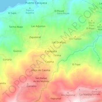
Name: Carayaca topographic map, elevation, terrain.
Average elevation: 2,438 ft
Minimum elevation: 0 ft
Maximum elevation: 5,630 ft
Make a donation
Gear up for your next adventure:
As an Amazon Associate, this site earns from qualifying purchases at no extra cost to you.
Other topographic maps
Click on a map to view its topography, its elevation and its terrain.
Parroquia La Guaira
Venezuela > Estado Vargas > Municipio Vargas
En 1867 se inicia el levantamiento topográfico para la línea de ferrocarril La Guaira-Caracas. La capital de Venezuela, Caracas, está situada a solo 11 km del mar Caribe pero a una altitud de 914 metros, empresas británicas y estadounidenses se disputaron durante 14 años la ruta y su financiamiento.…
Average elevation: 1,568 ft
Make a donation
Gear up for your next adventure:
As an Amazon Associate, this site earns from qualifying purchases at no extra cost to you.
Playa Puerto Viejo
Venezuela > Estado Vargas > Municipio Vargas > Catia La Mar
Average elevation: 49 ft
Playa Carmen de Uria
Venezuela > Estado Vargas > Municipio Vargas > Caraballeda > Antiguo Carmen de Uría
Average elevation: 361 ft