
Thank you for supporting this site ❤️
Make a donation
Make a donation
Gear up for your next adventure:
As an Amazon Associate, this site earns from qualifying purchases at no extra cost to you.
Glencoe topographic map
Click on the map to display elevation.
Thank you for supporting this site ❤️
Make a donation
Make a donation
Gear up for your next adventure:
As an Amazon Associate, this site earns from qualifying purchases at no extra cost to you.
About this map
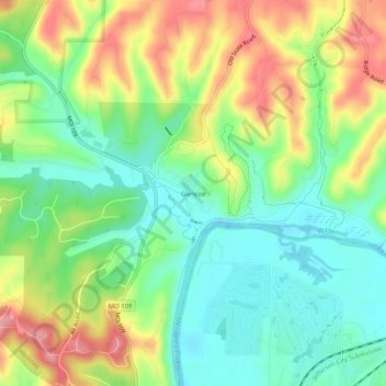
Name: Glencoe topographic map, elevation, terrain.
Average elevation: 564 ft
Minimum elevation: 397 ft
Maximum elevation: 817 ft
Saint Louis County trails, hiking, mountain biking, running and outdoor activities
Thank you for supporting this site ❤️
Make a donation
Make a donation
Gear up for your next adventure:
As an Amazon Associate, this site earns from qualifying purchases at no extra cost to you.
Other topographic maps
Click on a map to view its topography, its elevation and its terrain.
Dr. Edmund A. Babler Memorial State Park
United States > Missouri > Saint Louis County > Wildwood
Average elevation: 614 ft
Dr. Edmund A. Babler Memorial State Park
United States > Missouri > Saint Louis County > Wildwood
Average elevation: 614 ft