
Make a donation
Gear up for your next adventure:
As an Amazon Associate, this site earns from qualifying purchases at no extra cost to you.
Ledegem topographic map
Click on the map to display elevation.
Make a donation
Gear up for your next adventure:
As an Amazon Associate, this site earns from qualifying purchases at no extra cost to you.
Ledegem
Ledegem ligt in Zandlemig Vlaanderen. De hoogte verloopt van 20-32 meter, en de kerkdrempel ligt op 21 meter hoogte. De Heulebeek loopt in het zuiden langs de dorpskern, de Papelandbeek loopt in het westen, in het noorden loopt de Koolsdambeek en in het noordwesten de Papelandbeek.
Make a donation
Gear up for your next adventure:
As an Amazon Associate, this site earns from qualifying purchases at no extra cost to you.
About this map
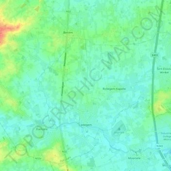
Name: Ledegem topographic map, elevation, terrain.
Location: Ledegem, Roeselare, West-Vlaanderen, 8880, België (50.84764 3.09452 50.89267 3.20886)
Average elevation: 82 ft
Minimum elevation: 46 ft
Maximum elevation: 180 ft
Make a donation
Gear up for your next adventure:
As an Amazon Associate, this site earns from qualifying purchases at no extra cost to you.
Other topographic maps
Click on a map to view its topography, its elevation and its terrain.
Beitem
België > West-Vlaanderen > Roeselare > Roeselare
Beitem ligt in Zandlemig Vlaanderen op een hoogte van ongeveer 32 meter. De belangrijkste waterloop is de Papelandbeek.
Average elevation: 85 ft