
Make a donation
Gear up for your next adventure:
As an Amazon Associate, this site earns from qualifying purchases at no extra cost to you.
Mandurriao topographic map
Click on the map to display elevation.
Make a donation
Gear up for your next adventure:
As an Amazon Associate, this site earns from qualifying purchases at no extra cost to you.
About this map
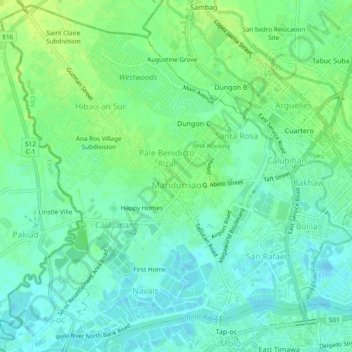
Name: Mandurriao topographic map, elevation, terrain.
Location: Mandurriao, Iloilo City, Western Visayas, 5000, Philippines (10.69647 122.51308 10.74156 122.56026)
Average elevation: 23 ft
Minimum elevation: -13 ft
Maximum elevation: 49 ft
Make a donation
Gear up for your next adventure:
As an Amazon Associate, this site earns from qualifying purchases at no extra cost to you.
Other topographic maps
Click on a map to view its topography, its elevation and its terrain.
Land Heigths III Subdivision Phase II
Philippines > Iloilo City > Jaro > Land Heigths III Subdivision Phase II
Average elevation: 23 ft
Make a donation
Gear up for your next adventure:
As an Amazon Associate, this site earns from qualifying purchases at no extra cost to you.