
Make a donation
Gear up for your next adventure:
As an Amazon Associate, this site earns from qualifying purchases at no extra cost to you.
Mount Zion topographic map
Click on the map to display elevation.
Make a donation
Gear up for your next adventure:
As an Amazon Associate, this site earns from qualifying purchases at no extra cost to you.
About this map
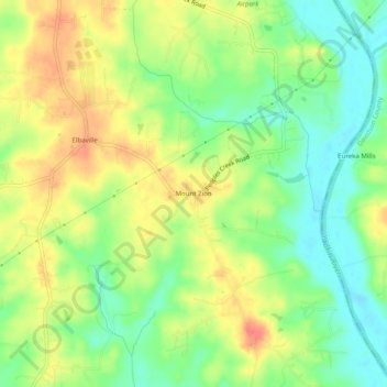
Name: Mount Zion topographic map, elevation, terrain.
Location: Mount Zion, Davie County, North Carolina, United States (35.89597 -80.41144 35.93597 -80.37144)
Average elevation: 741 ft
Minimum elevation: 656 ft
Maximum elevation: 837 ft
Davie County trails, hiking, mountain biking, running and outdoor activities
Make a donation
Gear up for your next adventure:
As an Amazon Associate, this site earns from qualifying purchases at no extra cost to you.
Other topographic maps
Click on a map to view its topography, its elevation and its terrain.
Carter Creek
United States > North Carolina > Davie County > Raintree Estates
Average elevation: 728 ft