
Make a donation
Gear up for your next adventure:
As an Amazon Associate, this site earns from qualifying purchases at no extra cost to you.
Mount Pleasant topographic map
Click on the map to display elevation.
Make a donation
Gear up for your next adventure:
As an Amazon Associate, this site earns from qualifying purchases at no extra cost to you.
Mount Pleasant
Mount Pleasant is a town situated in the Barossa Council, just north of the Adelaide Hills region of South Australia, 55 kilometres east-north-east of the state capital, Adelaide (34°46′S 139°3′E / 34.767°S 139.050°E / -34.767; 139.050). It is located in the Barossa Council and Mid Murray Council local government areas, and is at an altitude of 440 metres above sea level. Rainfall in the area averages 687 mm per annum.
Make a donation
Gear up for your next adventure:
As an Amazon Associate, this site earns from qualifying purchases at no extra cost to you.
About this map
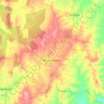
Name: Mount Pleasant topographic map, elevation, terrain.
Average elevation: 1,407 ft
Minimum elevation: 958 ft
Maximum elevation: 1,827 ft
Make a donation
Gear up for your next adventure:
As an Amazon Associate, this site earns from qualifying purchases at no extra cost to you.
Other topographic maps
Click on a map to view its topography, its elevation and its terrain.
Adelaide
Australia > South Australia > Adelaide
South Australia was officially established as a British Province in England in February 1836. The first Governor proclaimed the commencement of colonial government in South Australia on 28 December 1836, near The Old Gum Tree in what is now the suburb of Glenelg North. The event is commemorated in South…
Average elevation: 486 ft
Cooper Creek
Australia > South Australia > Pastoral Unincorporated Area > Innamincka
Average elevation: 128 ft
Make a donation
Gear up for your next adventure:
As an Amazon Associate, this site earns from qualifying purchases at no extra cost to you.
Ellis Park
Australia > South Australia > Adelaide City Council > Adelaide
Adelaide is a planned city, and the Adelaide Park Lands are an integral part of Colonel William Light's 1837 plan. Light chose a site spanning the River Torrens (known as Yatala by the Kaurna people), and planned the city to fit the topography of the landscape, "on rising ground".
Average elevation: 108 ft
Make a donation
Gear up for your next adventure:
As an Amazon Associate, this site earns from qualifying purchases at no extra cost to you.
Make a donation
Gear up for your next adventure:
As an Amazon Associate, this site earns from qualifying purchases at no extra cost to you.
Make a donation
Gear up for your next adventure:
As an Amazon Associate, this site earns from qualifying purchases at no extra cost to you.
Unnamed (No.HA565) Heritage Agreement
Australia > South Australia > Kangaroo Island Council
Average elevation: 636 ft