
Make a donation
Gear up for your next adventure:
As an Amazon Associate, this site earns from qualifying purchases at no extra cost to you.
Ulysses topographic map
Click on the map to display elevation.
Make a donation
Gear up for your next adventure:
As an Amazon Associate, this site earns from qualifying purchases at no extra cost to you.
About this map
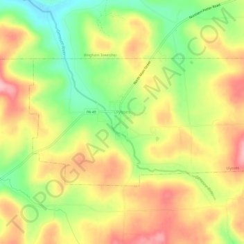
Name: Ulysses topographic map, elevation, terrain.
Location: Ulysses, Potter County, Pennsylvania, United States (41.89098 -77.78368 41.91329 -77.72658)
Average elevation: 2,201 ft
Minimum elevation: 1,936 ft
Maximum elevation: 2,448 ft
Make a donation
Gear up for your next adventure:
As an Amazon Associate, this site earns from qualifying purchases at no extra cost to you.
Other topographic maps
Click on a map to view its topography, its elevation and its terrain.
Sharon Center
United States > Pennsylvania > Potter County > Sharon Township
Average elevation: 1,739 ft
Cross Fork
United States > Pennsylvania > Potter County > Stewardson Township
Average elevation: 1,532 ft
Make a donation
Gear up for your next adventure:
As an Amazon Associate, this site earns from qualifying purchases at no extra cost to you.
Cross Fork
United States > Pennsylvania > Potter County > Stewardson Township
Average elevation: 1,532 ft
Patterson State Park
United States > Pennsylvania > Potter County > Summit Township
Average elevation: 2,323 ft
Kinney
United States > Pennsylvania > Potter County > Genesee Township > Kinney
Average elevation: 2,165 ft
Clara
United States > Pennsylvania > Potter County > Clara Township > Clara
Average elevation: 1,949 ft
Make a donation
Gear up for your next adventure:
As an Amazon Associate, this site earns from qualifying purchases at no extra cost to you.