
Make a donation
Gear up for your next adventure:
As an Amazon Associate, this site earns from qualifying purchases at no extra cost to you.
Distrito de Canoas de Punta Sal topographic map
Click on the map to display elevation.
Make a donation
Gear up for your next adventure:
As an Amazon Associate, this site earns from qualifying purchases at no extra cost to you.
About this map
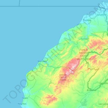
Name: Distrito de Canoas de Punta Sal topographic map, elevation, terrain.
Location: Distrito de Canoas de Punta Sal, Tumbes, Perú (-4.71229 -81.58997 -3.31229 -80.18997)
Average elevation: 518 ft
Minimum elevation: -7 ft
Maximum elevation: 5,013 ft
Make a donation
Gear up for your next adventure:
As an Amazon Associate, this site earns from qualifying purchases at no extra cost to you.
Other topographic maps
Click on a map to view its topography, its elevation and its terrain.
Río Tumbes
La cuenca alta del río Puyango-Tumbes, está rodeada por terrenos montañosos con altitudes de alrededor de 3.500 m. Cuatro tributarios principales: el río Calera, el río Amarillo, el río Luis y el río Ambocas, dan origen y forman el río Pindo. El río Pindo y sus tributarios tienen una pendiente…
Average elevation: 1,273 ft
Make a donation
Gear up for your next adventure:
As an Amazon Associate, this site earns from qualifying purchases at no extra cost to you.
Parque Nacional Cerros de Amotape
El parque cuenta con una extensión de 91 300 ha distribuidas entre las cotas altitudinales que van de los 200 m hasta los 1613 m s. n. m. La configuración variada de su relieve abarca colinas y cerros de la cadena de La Brea o Amotape. El lugar presenta un clima cálido-seco caracterizado por presentar una…
Average elevation: 1,355 ft
Make a donation
Gear up for your next adventure:
As an Amazon Associate, this site earns from qualifying purchases at no extra cost to you.
Make a donation
Gear up for your next adventure:
As an Amazon Associate, this site earns from qualifying purchases at no extra cost to you.
Concesión para Conservación Universidad Nacional de Tumbes
Perú > Tumbes > San Juan de la Virgen > Garbanzal
Average elevation: 184 ft
Make a donation
Gear up for your next adventure:
As an Amazon Associate, this site earns from qualifying purchases at no extra cost to you.