
Thank you for supporting this site ❤️
Make a donation
Make a donation
Gear up for your next adventure:
As an Amazon Associate, this site earns from qualifying purchases at no extra cost to you.
Moncé topographic map
Click on the map to display elevation.
Thank you for supporting this site ❤️
Make a donation
Make a donation
Gear up for your next adventure:
As an Amazon Associate, this site earns from qualifying purchases at no extra cost to you.
About this map
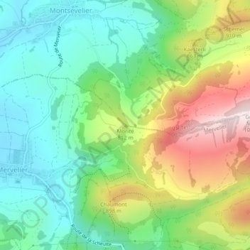
Name: Moncé topographic map, elevation, terrain.
Location: Moncé, Val Terbi, District de Delémont, Jura, 2824, Suisse (47.34859 7.51646 47.34869 7.51656)
Average elevation: 2,395 ft
Minimum elevation: 1,801 ft
Maximum elevation: 3,488 ft
Thank you for supporting this site ❤️
Make a donation
Make a donation
Gear up for your next adventure:
As an Amazon Associate, this site earns from qualifying purchases at no extra cost to you.