
Make a donation
Gear up for your next adventure:
As an Amazon Associate, this site earns from qualifying purchases at no extra cost to you.
Armour topographic map
Click on the map to display elevation.
Make a donation
Gear up for your next adventure:
As an Amazon Associate, this site earns from qualifying purchases at no extra cost to you.
About this map
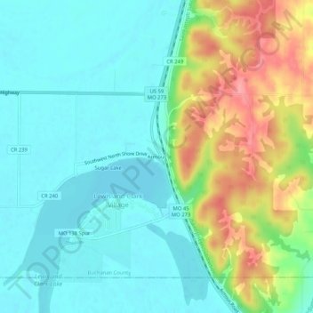
Name: Armour topographic map, elevation, terrain.
Location: Armour, Buchanan County, Missouri, 64484, United States (39.52861 -95.06636 39.56861 -95.02636)
Average elevation: 866 ft
Minimum elevation: 768 ft
Maximum elevation: 1,093 ft
Buchanan County trails, hiking, mountain biking, running and outdoor activities
Make a donation
Gear up for your next adventure:
As an Amazon Associate, this site earns from qualifying purchases at no extra cost to you.
Other topographic maps
Click on a map to view its topography, its elevation and its terrain.
Dearborn Reservoir Dam
United States > Missouri > Buchanan County > Dearborn
Average elevation: 948 ft
Make a donation
Gear up for your next adventure:
As an Amazon Associate, this site earns from qualifying purchases at no extra cost to you.