Geolocate

Pulo topographic map

Click on the map to display elevation.

About this map

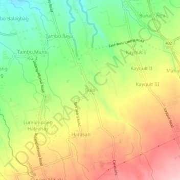
Name: Pulo topographic map, elevation, terrain.

Location: Pulo, Indang, Cavite, Calabarzon, 4122, Philippines (14.14972 120.85209 14.18972 120.89209)

Average elevation: 1,171 ft

Minimum elevation: 873 ft

Maximum elevation: 1,480 ft

Gear up for your next adventure:

🩳Quick‑Dry Hiking Shorts - Comfortable and quick‑dry shorts for summer hiking
🧤Tactile Hiking Gloves - Keep hands warm while operating GPS and smartphone screens
Solar GPS Watches - Advanced multisport watches with built-in topographic maps
🗃️Trail First Aid Kit - Essential kit for outdoor injuries and emergencies
🔥Plasma Lighters - Windproof lighters that work in any weather condition

As an Amazon Associate, this site earns from qualifying purchases at no extra cost to you.