
Thank you for supporting this site ❤️
Make a donation
Make a donation
Gear up for your next adventure:
As an Amazon Associate, this site earns from qualifying purchases at no extra cost to you.
Renlies topographic map
Click on the map to display elevation.
Thank you for supporting this site ❤️
Make a donation
Make a donation
Gear up for your next adventure:
As an Amazon Associate, this site earns from qualifying purchases at no extra cost to you.
About this map
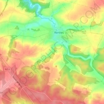
Name: Renlies topographic map, elevation, terrain.
Location: Renlies, Beaumont, Thuin, Hainaut, Wallonie, Belgique (50.15889 4.23271 50.20395 4.30352)
Average elevation: 755 ft
Minimum elevation: 577 ft
Maximum elevation: 892 ft
Thank you for supporting this site ❤️
Make a donation
Make a donation
Gear up for your next adventure:
As an Amazon Associate, this site earns from qualifying purchases at no extra cost to you.