
Make a donation
Gear up for your next adventure:
As an Amazon Associate, this site earns from qualifying purchases at no extra cost to you.
Janiuay topographic map
Click on the map to display elevation.
Make a donation
Gear up for your next adventure:
As an Amazon Associate, this site earns from qualifying purchases at no extra cost to you.
Janiuay
Santo Tomas approximate population is 500–800. Santo Tomas (Pakol to locals) is bounded by Madong in the east, Mangil in the north-east and Danao in the south west. It is accessible by three class C feeder roads in the east, south-west and south-east. Agriculture centers around rice, corn, coffee, beans, sugar cane, and copra. Traces of sweet mango farms are starting to gain roots especially close by the public elementary school. General topography is flat rice fields on the east and hill-valley-hill dotted by bamboos, coffee, mango, banana, coconuts and other fruit tree crops in the remaining areas. Water source are via deepwells and rice produce is primarily dependent on rainfall.
Make a donation
Gear up for your next adventure:
As an Amazon Associate, this site earns from qualifying purchases at no extra cost to you.
About this map
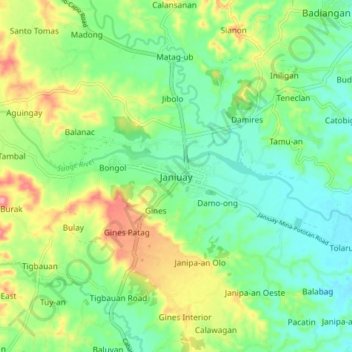
Name: Janiuay topographic map, elevation, terrain.
Location: Janiuay, Iloilo, Western Visayas, 5034, Philippines (10.90915 122.46196 10.98915 122.54196)
Average elevation: 269 ft
Minimum elevation: 138 ft
Maximum elevation: 522 ft
Make a donation
Gear up for your next adventure:
As an Amazon Associate, this site earns from qualifying purchases at no extra cost to you.