Geolocate

Madran topographic map

Interactive map

Click on the map to display elevation.

About this map

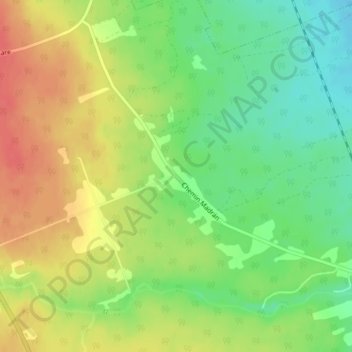
Name: Madran topographic map, elevation, terrain.

Location: Madran, Beresford Parish, Comté de Gloucester, Nouveau-Brunswick, E8J 2T7, Canada (47.80695 -65.78220 47.82695 -65.76220)

Average elevation: 161 ft

Minimum elevation: 69 ft

Maximum elevation: 253 ft

Other topographic maps

Click on a map to view its topography, its elevation and its terrain.

Nigadoo

Canada > Nouveau-Brunswick > Beresford Parish

Nigadoo, Beresford Parish, Comté de Gloucester, Nouveau-Brunswick, Canada

Average elevation: 39 ft

Petit-Rocher

Canada > Nouveau-Brunswick > Beresford Parish > Petit-Rocher

Petit-Rocher, Beresford Parish, Comté de Gloucester, Nouveau-Brunswick, E8J 1S5, Canada

Average elevation: 33 ft