
Make a donation
Gear up for your next adventure:
As an Amazon Associate, this site earns from qualifying purchases at no extra cost to you.
Serra da Santa topographic map
Click on the map to display elevation.
Make a donation
Gear up for your next adventure:
As an Amazon Associate, this site earns from qualifying purchases at no extra cost to you.
About this map
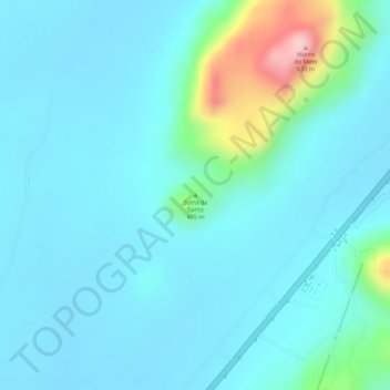
Name: Serra da Santa topographic map, elevation, terrain.
Average elevation: 1,414 ft
Minimum elevation: 1,293 ft
Maximum elevation: 2,018 ft
Make a donation
Gear up for your next adventure:
As an Amazon Associate, this site earns from qualifying purchases at no extra cost to you.
Other topographic maps
Click on a map to view its topography, its elevation and its terrain.
Portal da Cidade
Brasil > Pernambuco > Região Administrativa Integrada de Desenvolvimento do Polo Petrolina e Juazeiro > Petrolina
Average elevation: 1,257 ft
Vale do Grande Rio
Brasil > Pernambuco > Região Administrativa Integrada de Desenvolvimento do Polo Petrolina e Juazeiro > Petrolina
Average elevation: 1,237 ft
Boa Esperança - Estrada das Pedrinhas
Brasil > Pernambuco > Região Administrativa Integrada de Desenvolvimento do Polo Petrolina e Juazeiro > Petrolina
Average elevation: 1,234 ft
Dom Avelar
Brasil > Pernambuco > Região Administrativa Integrada de Desenvolvimento do Polo Petrolina e Juazeiro > Petrolina
Average elevation: 1,266 ft
Make a donation
Gear up for your next adventure:
As an Amazon Associate, this site earns from qualifying purchases at no extra cost to you.
Terras Alphaville
Brasil > Pernambuco > Região Administrativa Integrada de Desenvolvimento do Polo Petrolina e Juazeiro > Petrolina
Average elevation: 1,224 ft
Rajada
Brasil > Pernambuco > Região Administrativa Integrada de Desenvolvimento do Polo Petrolina e Juazeiro > Petrolina
Average elevation: 1,453 ft
Areia Branca
Brasil > Pernambuco > Região Administrativa Integrada de Desenvolvimento do Polo Petrolina e Juazeiro > Petrolina
Average elevation: 1,257 ft
Curral Queimado
Brasil > Pernambuco > Região Administrativa Integrada de Desenvolvimento do Polo Petrolina e Juazeiro > Petrolina
Average elevation: 1,378 ft
Make a donation
Gear up for your next adventure:
As an Amazon Associate, this site earns from qualifying purchases at no extra cost to you.