Geolocate

Bloomington topographic map

Click on the map to display elevation.

About this map

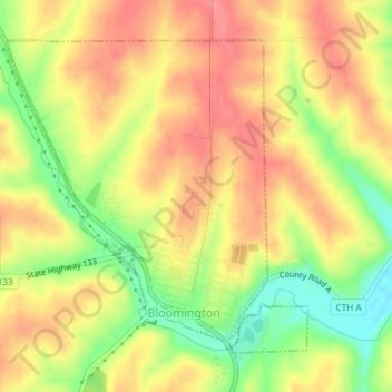
Name: Bloomington topographic map, elevation, terrain.

Location: Bloomington, Grant County, Wisconsin, United States (42.88042 -90.94138 42.90194 -90.91300)

Average elevation: 984 ft

Minimum elevation: 837 ft

Maximum elevation: 1,083 ft

Grant County trails, hiking, mountain biking, running and outdoor activities

Other topographic maps

Click on a map to view its topography, its elevation and its terrain.

Mississippi River

United States > Wisconsin > Grant County > Dubuque

The uppermost lock and dam on the Upper Mississippi River is the Upper St. Anthony Falls Lock and Dam in Minneapolis. Above the dam, the river's elevation is 799 feet (244 m). Below the dam, the river's elevation is 750 feet (230 m). This 49-foot (15 m) drop is the largest of all the Mississippi River locks…

Average elevation: 666 ft

Van Buren

United States > Wisconsin > Grant County > Potosi

Average elevation: 794 ft

Stitzer

United States > Wisconsin > Grant County

Average elevation: 1,086 ft

Sinsinawa

United States > Wisconsin > Grant County

Average elevation: 909 ft

Sandy Hook

United States > Wisconsin > Grant County

Average elevation: 804 ft

Kieler

United States > Wisconsin > Grant County

Average elevation: 902 ft

Gear up for your next adventure:

🔭Compact Binoculars - HD vision for scouting terrain and identifying distant landmarks
🌧️Backpack Rain Cover - Keep gear dry in wet weather
🔭Telescopic Hiking Pole - Adjustable pole for hiking stability
Backpacking Tent - Lightweight and durable tent for multi‑day hikes
🔦Compact Flashlight - Reliable flashlight for emergencies

As an Amazon Associate, this site earns from qualifying purchases at no extra cost to you.