
Thank you for supporting this site ❤️
Make a donation
Make a donation
Gear up for your next adventure:
As an Amazon Associate, this site earns from qualifying purchases at no extra cost to you.
Hirschberg topographic map
Click on the map to display elevation.
Thank you for supporting this site ❤️
Make a donation
Make a donation
Gear up for your next adventure:
As an Amazon Associate, this site earns from qualifying purchases at no extra cost to you.
About this map
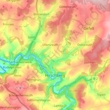
Name: Hirschberg topographic map, elevation, terrain.
Location: Hirschberg, Saale-Orla-Kreis, Thuringia, 07927, Germany (50.38972 11.74932 50.44675 11.87610)
Average elevation: 1,795 ft
Minimum elevation: 1,381 ft
Maximum elevation: 2,139 ft
Thank you for supporting this site ❤️
Make a donation
Make a donation
Gear up for your next adventure:
As an Amazon Associate, this site earns from qualifying purchases at no extra cost to you.