
Thank you for supporting this site ❤️
Make a donation
Make a donation
Gear up for your next adventure:
As an Amazon Associate, this site earns from qualifying purchases at no extra cost to you.
Rapoula topographic map
Click on the map to display elevation.
Thank you for supporting this site ❤️
Make a donation
Make a donation
Gear up for your next adventure:
As an Amazon Associate, this site earns from qualifying purchases at no extra cost to you.
About this map
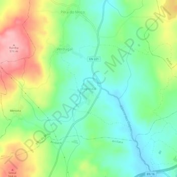
Name: Rapoula topographic map, elevation, terrain.
Location: Rapoula, Guarda, 6300-000, Portugal (40.57577 -7.22685 40.61577 -7.18685)
Average elevation: 2,808 ft
Minimum elevation: 2,598 ft
Maximum elevation: 3,186 ft
Thank you for supporting this site ❤️
Make a donation
Make a donation
Gear up for your next adventure:
As an Amazon Associate, this site earns from qualifying purchases at no extra cost to you.