
Make a donation
Gear up for your next adventure:
As an Amazon Associate, this site earns from qualifying purchases at no extra cost to you.
Seilersee topographic map
Click on the map to display elevation.
Make a donation
Gear up for your next adventure:
As an Amazon Associate, this site earns from qualifying purchases at no extra cost to you.
About this map
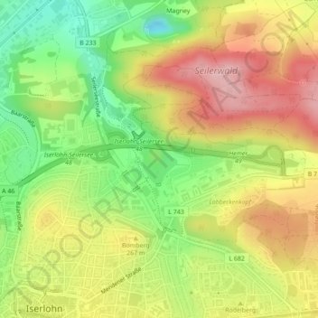
Name: Seilersee topographic map, elevation, terrain.
Average elevation: 807 ft
Minimum elevation: 495 ft
Maximum elevation: 1,106 ft
Make a donation
Gear up for your next adventure:
As an Amazon Associate, this site earns from qualifying purchases at no extra cost to you.
Other topographic maps
Click on a map to view its topography, its elevation and its terrain.
Make a donation
Gear up for your next adventure:
As an Amazon Associate, this site earns from qualifying purchases at no extra cost to you.
Drüpplingsen
Deutschland > Nordrhein-Westfalen > Märkischer Kreis > Iserlohn
Average elevation: 486 ft
Make a donation
Gear up for your next adventure:
As an Amazon Associate, this site earns from qualifying purchases at no extra cost to you.
Stenglingsen
Deutschland > Nordrhein-Westfalen > Märkischer Kreis > Iserlohn
Average elevation: 735 ft
Make a donation
Gear up for your next adventure:
As an Amazon Associate, this site earns from qualifying purchases at no extra cost to you.
Leckingsen
Deutschland > Nordrhein-Westfalen > Märkischer Kreis > Iserlohn > Kalthof
Average elevation: 633 ft
Hegenscheid
Deutschland > Nordrhein-Westfalen > Märkischer Kreis > Iserlohn
Average elevation: 1,273 ft