
Manchester topographic map
Click on the map to display elevation.
Manchester
According to the United States Census Bureau, the city has a total area of 34.9 square miles (90.5 km2), of which 33.1 square miles (85.7 km2) are land and 1.9 square miles (4.8 km2) are water, comprising 5.33% of the city. Manchester is drained by the Merrimack River and its tributaries the Piscataquog River and Cohas Brook. Massabesic Lake is on the eastern border. The highest point in Manchester is atop Wellington Hill, where the elevation reaches 570 feet (170 m) above sea level.
About this map
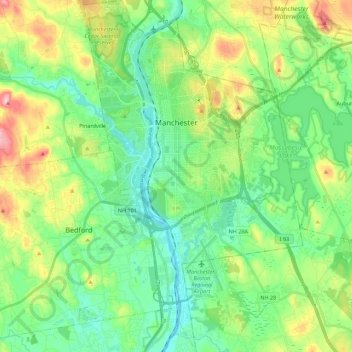
Name: Manchester topographic map, elevation, terrain.
Average elevation: 315 ft
Minimum elevation: 105 ft
Maximum elevation: 804 ft
Hillsborough County trails, hiking, mountain biking, running and outdoor activities
Other topographic maps
Click on a map to view its topography, its elevation and its terrain.
Souhegan River Watershed Dam Number 35
United States > New Hampshire > Hillsborough County > New Ipswich > Smithville
Average elevation: 1,145 ft
Souhegan River
United States > New Hampshire > Hillsborough County > Milford > East Milford
Average elevation: 276 ft
Joe English Hill
United States > New Hampshire > Hillsborough County > New Boston
Average elevation: 810 ft
Piscataquog River
United States > New Hampshire > Hillsborough County > Manchester
Average elevation: 194 ft
South Uncanoonuc Mountain
United States > New Hampshire > Hillsborough County > Goffstown
Average elevation: 797 ft
New Ipswich Center
United States > New Hampshire > Hillsborough County > New Ipswich
Average elevation: 1,063 ft
Souhegan River
United States > New Hampshire > Hillsborough County > Milford > East Milford
Average elevation: 276 ft
West Peterborough
United States > New Hampshire > Hillsborough County > Peterborough
Average elevation: 981 ft
South Weare
United States > New Hampshire > Hillsborough County > Weare > South Weare
Average elevation: 689 ft
Hillsboro Lower Village
United States > New Hampshire > Hillsborough County > Hillsborough
Average elevation: 794 ft
Campbell Mountain
United States > New Hampshire > Hillsborough County > Hillsborough
Average elevation: 1,109 ft
North Brookline
United States > New Hampshire > Hillsborough County > Brookline > North Brookline
Average elevation: 407 ft
Nakuru Lake
United States > New Hampshire > Hillsborough County > Hudson > Hudson Center
Average elevation: 262 ft
Massachusetts Drive Park
United States > New Hampshire > Hillsborough County > Nashua
Average elevation: 157 ft