Geolocate

Camagüey topographic map

Interactive map

Click on the map to display elevation.

About this map

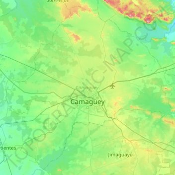
Name: Camagüey topographic map, elevation, terrain.

Location: Camagüey, Cuba (21.20315 -78.14655 21.62603 -77.66001)

Average elevation: 315 ft

Minimum elevation: 112 ft

Maximum elevation: 1,047 ft

Other topographic maps

Click on a map to view its topography, its elevation and its terrain.

Clarita

Cuba > Camagüey > Vertientes

Clarita, Vertientes, Camagüey, Cuba

Average elevation: 187 ft

Quemado

Cuba > Camagüey

Quemado, Esmeralda, Camagüey, Cuba

Average elevation: 95 ft

Cayo Puto

Cuba > Camagüey > Nuevitas

Cayo Puto, Nuevitas, Camagüey, Cuba

Average elevation: 59 ft

Quemado

Cuba > Camagüey

Quemado, Esmeralda, Camagüey, Cuba

Average elevation: 33 ft

Cabeza de Vaca

Cuba > Camagüey > Camagüey

Cabeza de Vaca, Camagüey, Cuba

Average elevation: 371 ft