
Make a donation
Gear up for your next adventure:
As an Amazon Associate, this site earns from qualifying purchases at no extra cost to you.
Riverwest topographic map
Click on the map to display elevation.
Make a donation
Gear up for your next adventure:
As an Amazon Associate, this site earns from qualifying purchases at no extra cost to you.
Riverwest
The Harambee community is just north of downtown Milwaukee and is bounded by Keefe Avenue to the north, Holton Street to the east, North Avenue to the south, and I-43 to the west. Harambee includes the highest residential elevation in the city, a tall ridge running along 1st Street. Between 1890 and 1910, well-to-do families built mansions on the North Side. Only a few are genuine mansions; the wealthiest Germans lived on the East and West Sides. Some are picturesque Queen Annes, with corner turrets and rambling floor plans. In 1984, the First Street corridor became an official historic district, listed on the National Register of Historic Places.
Make a donation
Gear up for your next adventure:
As an Amazon Associate, this site earns from qualifying purchases at no extra cost to you.
About this map
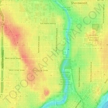
Name: Riverwest topographic map, elevation, terrain.
Location: Riverwest, Milwaukee, Wisconsin, 53201, United States (43.05577 -87.90538 43.08924 -87.89243)
Average elevation: 676 ft
Minimum elevation: 571 ft
Maximum elevation: 745 ft
Wisconsin trails, hiking, mountain biking, running and outdoor activities
Make a donation
Gear up for your next adventure:
As an Amazon Associate, this site earns from qualifying purchases at no extra cost to you.