
Thank you for supporting this site ❤️
Make a donation
Make a donation
Gear up for your next adventure:
As an Amazon Associate, this site earns from qualifying purchases at no extra cost to you.
Tinajones topographic map
Click on the map to display elevation.
Thank you for supporting this site ❤️
Make a donation
Make a donation
Gear up for your next adventure:
As an Amazon Associate, this site earns from qualifying purchases at no extra cost to you.
About this map
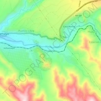
Name: Tinajones topographic map, elevation, terrain.
Location: Tinajones, El Filtro, Uchumayo, Arequipa, 04000, Perú (-16.45196 -71.67227 -16.41196 -71.63227)
Average elevation: 6,916 ft
Minimum elevation: 6,371 ft
Maximum elevation: 7,703 ft
Thank you for supporting this site ❤️
Make a donation
Make a donation
Gear up for your next adventure:
As an Amazon Associate, this site earns from qualifying purchases at no extra cost to you.