
Thank you for supporting this site ❤️
Make a donation
Make a donation
Gear up for your next adventure:
As an Amazon Associate, this site earns from qualifying purchases at no extra cost to you.
Dayuno topographic map
Click on the map to display elevation.
Thank you for supporting this site ❤️
Make a donation
Make a donation
Gear up for your next adventure:
As an Amazon Associate, this site earns from qualifying purchases at no extra cost to you.
About this map
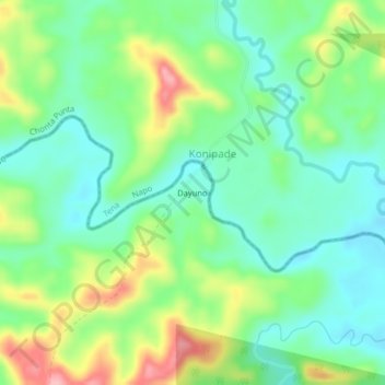
Name: Dayuno topographic map, elevation, terrain.
Location: Dayuno, Curaray, Arajuno, Pastaza, Ecuador (-1.10670 -77.41206 -1.06670 -77.37206)
Average elevation: 1,119 ft
Minimum elevation: 965 ft
Maximum elevation: 1,417 ft
Thank you for supporting this site ❤️
Make a donation
Make a donation
Gear up for your next adventure:
As an Amazon Associate, this site earns from qualifying purchases at no extra cost to you.